| INTerferometric Evaluation of Glaciers Rheology and ALteration (INTEGRAL FP6 project). | ||||||
|---|---|---|---|---|---|---|
Glaciers give an example of one of the most dynamic objects on the Earth surface, at once they indicate reliably climatic changes. In addition, the state of glaciers and their change tendencies are very important not only for scientists, but also in socio-economic sphere, especially for areas where glaciers’ activity and glaciers-provided water resources play an essential role for the safe and stable development of the region. The international project INTEGRAL («INTerferometric Evaluation of Glaciers Rheology and Alteration», project coordinator A. Sharov, Joanneum Research, Austria, see http://dib.joanneum.at/integral) with FIRE RAS as an active participant aims at promotion of advanced technique of remote sensing, such as automatic detection and high-quality estimation of land cover displacements, for examination large European glaciers’ dynamics in behalf of economical and environmental objectives. The key idea of the technique is a joint using of complementary high-accuracy methods of spaceborne radar interferometry, altimetry and altimetric interferometry. For processing and computational part of the project a large set of data from post-operational, operational and planned systems is involved: E-SAR, ERS-1/2, SRTM, ENVISAT, RADARSAT-1, 2, 3, ALOS, and CRYOSAT. Novel promising methods worked out within the framework of the project are trained for test sites that include alpine glaciers and also the largest European ice shelves of Svalbard, Franz-Josef Land, and the northern part of Novaya Zemlya. For correct estimation of a glacier mass balance one should use the complex model of the glacier, which includes geometric structure of the object, topography of neighborhood area, climatic factors, measurements of glacier velocities, frontal height, and the location of its frontal zone. SAR interferometry (InSAR), which is a high-accuracy tool for measuring the Earth surface dynamics, is one of the scientific directions of Radar Studies Laboratory of FIRE RAS. Interferometric methods proof to be a well-suited instrument for topographic measurements and estimation of the earth surface small-scale displacements in the line-of-sight direction for seismic areas, and also for man-made surface motion. Application of InSAR techniques for glaciology promises impressive results. One of the necessary conditions for displacement measurements by means of InSAR is repeat-pass scheme of radar observations. Time interval between two observations constitute a so-called temporal baseline, and we can measure displacement of the surface exactly for this time period. The longer temporal baseline, the lower signal coherence and the higher noise level in the interferogram (phase difference image). From that angle glaciers are dynamic and simultaneously steady in their scattering properties, thus glacier motion is detectable for the observations with 1-day time interval.
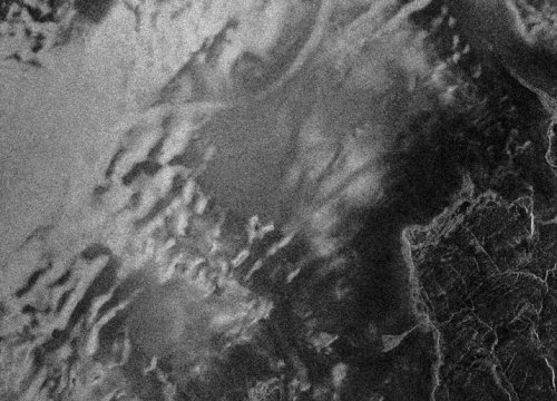
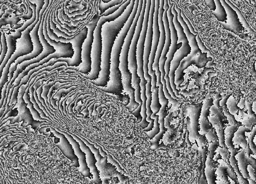
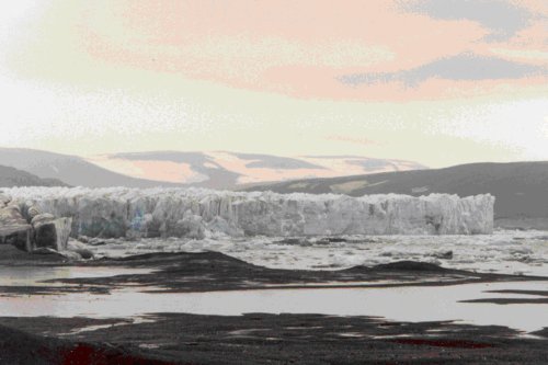
Fig. 1 gives an example of radar image of Shokal’skogo glacier (Novaya Zemlya) mapped by JERS-1 SAR in winter of 1997–1998, and the interferogram (generated in FIRE RAS) for the same area with 44-days time interval between observations is in the Fig. 2. Fig. 3 presents the picture of the glacier front (provided by Project Coordinator). The area of two glaciers and the direction of their motion are indicated by arrows in the amplitude image. The interferogram contains information on the local elevations (slowly changed interferometric fringes) and also the glacier’s dynamics (dense fringes bordering the glacier’s body). The glacier front velocity is too high for coherenr radar mapping, therefore the motion estimation for this part of glacier (about 1 meter per day) was performed by special offset-tracking techniques.
The necessity of improved distinction of topographic and motion effects in interferograms (in the case of lacking of ground truth and precise maps) results in using new interferogram processing methods as correlation, transferential and phase gradient approaches, and their combinations. High-accuracy altimetric data from space-based altimeters are of great importance for refinement of elevation models for interferometric processing, and also for estimation of glaciers thickness variations. One of the qualities of the project is extensive usage of altimetric information and perfection of combining altimeter, altimetric interferometry and radar interferometry data. One of the main goals of the INTEGRAL project is promotion of modern developing technologies and their transfer to end users, in the first place Russian ones.
|